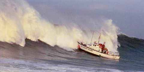
Maritime Operations
The coastal and inland waters of the Pacific Northwest have a long history of being used as transportation routes. Now, Oregon and Washington are home to over 20 ports that support many industries including:
- Commerce, trade, and shipping
- Commercial fishing
- Military facilities (Navy and Coast Guard)
- Cruise lines
- Ferry systems
- NOAA West Coast Ship Operations
- Renewable marine energy
- Recreational boating
Puget Sound, the Columbia River, and multiple other locations along the Washington and Oregon coastline are essential hubs to these industries, which are vital not just for the security, safety, and economy of Washington and Oregon, but for the whole country.
Areas of Emphasis
Maritime Operations |
Coastal Hazards |
Fisheries & Marine Life |
Marine Ecosystems |
Weather & Climate |
Related Topics
NVS Maritime Operations App
Observations and enhanced forecasts of nearshore waves and currents that are applicable to the maritime and fishing communities.
Coastal & Marine Spatial Planning
Related NANOOS Products
Forecast Information and Data Products for Tuna Fishers
Information and data products oriented towards commercial and recreational albacore tuna fishing communities.
NOAA NOS/CO-OPS Tide Prediction
Tide predictions from the National Oceanic and Atmospheric Science (NOAA) National Ocean Service (NOS)/Center for Operational Oceanographic Products & Services (CO-OPS).
OSU Regional Ocean Modeling System (ROMS) Surface Fields
Forecast map of water temperature and surface currents for the Oregon and SW Washington Coast.
WaveWatch III Wind and Wave Model
Forecasts for winds and waves in the North Pacific. Forecasts are updated every 6 hours starting at 13:00 PDT. Forecasts provided by the NOAA National Weather Service (NWS)/National Centers for Environmental Prediction (NCEP).
High-Frequency (HF) Radar Surface Currents
Observations of daily averaged ocean surface current speed and direction for the Oregon coast.
X-band Wave Imaging Marine Radar
Real-time wave observations in Newport, OR to investigate wave breaking and wave/current interaction processes at the inlet to Yaquina Bay.
NOAA National Data Buoy Center (NDBC)
Observations of air and water temperature, wind, barometric pressure, and waves.
New Dungeness, WA (View in NVS)
Cape Elizabeth, WA (View in NVS)
Columbia River Bar, OR (View in NVS)
Stonewall Banks, OR (View in NVS)
NOAA NOS/CO-OPS
Observations of water level, air and water temperature, barometric pressure, and winds from the National Oceanic and Atmospheric Science (NOAA) National Ocean Service (NOS)/Center for Operational Oceanographic Products & Services (CO-OPS).
Grays Harbor, WA (View in NVS)
NANOOS members involved in this effort include:
The Maritime Exchange of Puget Sound
Council of American Master Mariners
The Puget sound Harbor Safety Committee
Port of Neah Bay
| National Observing System Partners Alliance for Coastal Technologies (ACT) Southeastern Universities Research Association (SURA) Integrated Ocean Observing System IOOS | |||||||