Marine Ecosystems
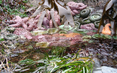
An ecosystem is defined by the physical space and the biology, including plants and animals, that live in that space. Different land ecosystems include forested mountains, grassy plains and dry deserts; marine ecosystems are just as diverse. In the Pacific Northwest, marine ecosystems range from the open ocean that is dominated by basin-wide forces, the coastal ocean that is influenced by seasonal upwelling events, and estuaries and bays that have both salt and freshwater flowing through them. All of these different marine ecosystems allow for a great diversity of habitats, which are necessary to support the many life stages of marine animals that call the Pacific Northwest home.

The dynamics of the coastal ocean in the Pacific Northwest are controlled and influenced by several regional- and large-scale factors that produce highly productive coastal and estuarine environments. The interaction of coastal currents with the contours of the ocean bottom and freshwater inputs from sources like the Columbia River and the Strait of Juan de Fuca, seasonal upwelling favorable winds that fuel phytoplankton blooms, and the south-flowing branch of the North Pacific Current, which moves water from Asia to North America, to form the California Current System, are some of the regional factors. Some of the important large-scale factors that shape our ecosystems are the Pacific Decadal Oscillation (PDO), which affects salmon survival in the ocean, and the El Niño Southern Oscillation (ENSO), which affects both ocean and weather conditions every 2-7 years.
Areas of Emphasis
Maritime Operations |
Coastal Hazards |
Fisheries & Marine Life |
Marine Ecosystems |
Weather & Climate |
Related Topics
Ocean Acidification
Harmful Algal Blooms
Coastal and Estuarine Hypoxia
Water Quality for Shellfish Growers
Marine Debris
Coastal & Marine Spatial Planning
Related NANOOS Products
CRITFC Coastal Margin Observation and Prediction Program (CMOP)
Near real-time data, forecasts, and climatological maps of physical and biogeochemical parameters in the Columbia River estuary, near plume, and coastal margins of Oregon and Washington.
High-Frequency (HF) Radar Surface Currents
Observations of daily averaged ocean surface current speed and direction for the Oregon coast.
NANOOS Visualization System (NVS)
The NANOOS Visualization System (NVS) provides easy access to forecast and observation data across a wide range of assets such as buoys, shore and land stations, high-frequency radar, and satellites.
OSU Regional Ocean Modeling System (ROMS) Surface Fields
Forecast map of water temperature and surface currents for the Oregon and SW Washington Coast.
Puget Sound Networked Profiling Buoy
Data from a profiling buoy located at Point Wells (north of Seattle). The sensor package measures a depth profile of oceanographic variables every hour from the sea surface to the sea bed.
Puget Sound ORCA
Oceanic Remote Chemical Analyzer (ORCA) measures physical, chemical, and biological water characteristics in Hood Canal.
Salish Cruise Data
Over ten years of processed PRISM cruise data starting in December 1998 to most recently processed from numerous Puget Sound locations. Data types include fluorescence, salinity, density, water temperature, transmissivity, and oxygen.
Water Quality Data for Shellfish Growers
Real-time Water Quality Data for Shellfish Growers. A pilot project between NANOOS and the National Estuarine Research Reserve System.
NANOOS members involved in this effort include:
Oregon Health and Sciences University
VENUS Observatory, Ocean Networks Canada
Western Association of Marine Laboratories
NOAA Olympic Coast National Marine Sanctuary
Oregon Dept. of Land Conservation & Development
| National Observing System Partners Alliance for Coastal Technologies (ACT) Southeastern Universities Research Association (SURA) Integrated Ocean Observing System IOOS | |||||||

